
UCO
VALLEY
high-mountain terroir
T
he terroirs in the Uco Valley are defined by the closeness to the mountain, the majestic cordillera de los Andes. The cordillera generates the semi-arid climate of Mendoza; the stones in our soils come from this place (cordillera) and it gives us the extreme altitude which is so characteristic of our terroir.
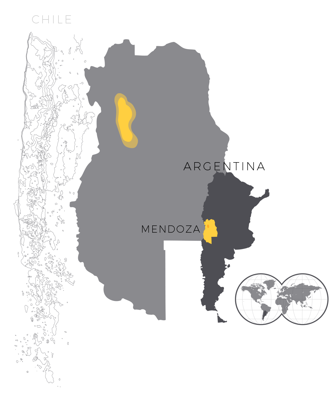
The province of Mendoza is a huge desert where there are some oases. In the north, there is the town of Mendoza, which was the destination of the first Spanish immigrants. A new oasis, called Valle de Uco (Uco valley), can be found 80 km south of the town. This valley houses what was for a long time the military border between the colonized Spanish area and the native people from the south of the province.
The Uco valley has been shaped by the Tunuyan river and its tributaries. This river “crosses” this valley in a south-west/north-east direction. It is an asymmetric valley that covers an area of 115 km from north to south. The Uco valley borders the Andes to the west (front part of the mountain range which reaches 6,000 m) and a series of small mountains (Sierra del Totoral, cerrillada de Tupungato, meseta del Guadal) to the east. The slanting shape of the Sierra del Totoral that joins the front part of the mountain range incloses the valley to the north, and to the south, this valley borders the elevation of the Guadal plateau.
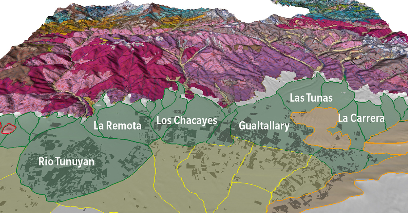
Aluvial fans of the Uco Valley
Generally speaking, the Uco valley can be divided into two geographical macro units: the piedmont (which descends towards the graben) and the loess plains (silts) to the east. The piedmont is made up of a union of several alluvial “fans” whose slope are very steep (up to 4%). These are gravelly soils traversed by a network of natural streams and drains. It is during the Pleistocene (2.5 million to 11,700 years ago) when the Andes rose, that these soils of the foothills were formed. The wet conditions of this geological time allowed a large quantity of rocks to descend, carried by rivers and glaciers. In the plains, formed by the most distal part of these alluvial fans, we find rich soils (silt) and a slope five times lower than in the foothills, with an average of 0.8%.
This valley includes three different towns: Tupungato to the north, Tunuyan in the center, and San Carlos to the south. These towns were built on very rich and fertile soils. The alluvial and poor soils can be found to the west, rising up to the mountains. They start at an altitude of 1,050 meters, reaching up to 1,500 meters. Fantastic terroirs can be found there: Gualtallary to the north (Tupungato), Chacayes in the center (Tunuyán), and Paraje Altamira and el Cepillo to the south (San Carlos).

Location Uco Valley in Mendoza Province
Climate
The climate of Mendoza is characterized by its closeness to the Andes. This altitude blocks the humid air mass that comes from Chile. Clouds formed on the Pacific Ocean lift to an altitude of 6,000 meters imposed by the central part of the mountain range. A drop in temperatures at that altitude leads the water vapor to its condensation, transforming it into precipitations. These precipitations will form huge ice reserves on the top of the mountain range, which will melt and therefore, supply the arid regions of Mendoza with water.
The Andes watches over our vineyards like an attentive mother. It protects them from atmospheric humidity (rainfall in Mendoza fluctuates between 250 and 400 mm), thus reducing the impact of vineyard pests and diseases. These vineyards are also irrigated with pure water by this mountain range. The average rainfall over the last twenty years (1998 to 2019) has been around 315 mm/year, which is very low and makes good irrigation management in our vineyards essential.
Altitude
The altitude has two effects on the vines. The first one is the thermal amplitude. The significant difference in temperature during the day and night increases the concentration of color and aromas in the grapes. Situated at an altitude of 1,100 – 1,300 masl, the vineyards we have chosen in Chacayes, Altamira and Gualtallary enjoy an ideal location with regards to thermal amplitude. Maximum temperatures are high (around 31° C), but, still, they remain moderated due to the altitude. Minimum temperatures are low (9° C) because they are affected by the cold air mass that goes down the mountains. The average thermal amplitude in the regions we have chosen fluctuates between 16 and 22°C, which is totally exceptional, even within the Uco valley.
The second consequence, not minor, of the altitude is the clear, strong and intense light that inundates our vineyards. This light also generates a slight stress on the plant that contributes to the concentration of aromas and color of our grapes.